Bhopal, May 8 (IANS) The India Meteorological Department in Bhopal has issued a comprehensive weather bulletin detailing a significant period of atmospheric instability across Madhya Pradesh.
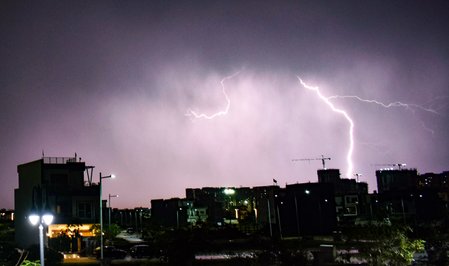
According to the press release issued on May 8, 2026, the state is currently navigating a complex weather pattern characterised by hailstorms, thunderstorms, and lightning, which are expected to persist through the next 24 hours.
The meteorological summary indicates that several regions have already experienced varied rainfall amounts, with Badarwas recording the highest at 16 millimeters, followed by Patharia and Majhgaon at twelve millimeters each.
Beyond precipitation, the state has been buffeted by intense wind gusts, reaching speeds of 80 kilometers per hour in Sagar and 67 kilometers per hour in Ashoknagar.
The forecast for the immediate future remains precarious, with the department issuing high-alert warnings for specific regions.
Between the morning of May 8 and May 9, districts such as Datia, Bhind, Chhindwara, Tikamgarh, Niwari, and Pandhurna are expected to face thunderstorms accompanied by lightning, hailstorms, and fierce wind gusts of 50 to 60 kilometers per hour.
Neighbouring areas, including Gwalior, Morena, Rewa, Jabalpur, and Sagar, are also on alert for similar conditions with slightly lower wind speeds of 40 to 50 kilometers per hour.
As the system moves, the warnings for May 9 to May 10 shift focus towards the southern and eastern belts, specifically affecting Betul, Anuppur, Chhindwara, and Seoni.
In the past 24-hour period leading up to the morning of May 8, 2026, rainfall and thunderstorms were reported across a wide swathe of districts including Bhind, Morena, Gwalior, Datia, Shivpuri, and Sheopur Kalan.
Other affected areas included Nivari, Tikamgarh, Chhatarpur, Panna, Satna, Rewa, Mauganj, Sagar, Damoh, Katni, Jabalpur, Betul, Chhindwada, Pandhurna, Mandla, and Anuppur.
Most alarmingly, actual hailstorms were confirmed in the districts of Morena, Shivpuri, and Chhatarpur.
These conditions are being driven by several synoptic systems, notably a Western Disturbance persisting as a cyclonic circulation over northwest Uttar Pradesh and adjoining Uttarakhand.
Additionally, multiple troughs are moving across central India, including one stretching from Comorin to southwest Madhya Pradesh, creating significant wind discontinuities at lower atmospheric levels.
Given the potential for damage to crops, livestock, and weak structures, authorities have issued detailed safety guidelines.
Farmers are urged to monitor standing crops and provide staking where necessary, or prioritise harvesting if the crop is ready for storage.
The public is advised to remain indoors during lightning strikes, avoid seeking shelter under trees, and unplug electronic devices to prevent damage from power surges.
Additionally, a health advisory has been included due to the increased risk of seasonal illnesses like the flu during such erratic weather, encouraging citizens to maintain their immunity through vitamin-rich diets. The department continues to monitor these systems closely to provide updated warnings as the situation evolves.
–IANS
sktr/rad