New Delhi, June 28: Located roughly 1,000 miles from the Indian mainland, Great Nicobar is one of the 500-plus islands that make up the Andaman and Nicobar archipelago. The island is historically tied to two distinct indigenous groups: the Shompen and the Great Nicobarese.
The Shompen are an isolated community of roughly 200 to 400 individuals who avoid the outside world and maintain a traditional lifestyle as some of the world’s last remaining hunter-gatherers and farmers. The Great Nicobarese originally inhabited the island’s western coastline until the catastrophic 2004 tsunami either claimed their lives or forced them to relocate.
Multi-Layered Security in the Indo-Pacific
In this era of intensifying strategic competition with China, Great Nicobar is not just a remote island but will soon be a critical geopolitical asset for India upon completion of the project. Situated 40 nautical miles from the Strait of Malacca – the conduit for over 80% of China’s oil imports – this strategic vantage point empowers India to monitor, influence and secure this invaluable maritime chokepoint by enabling continuous surveillance over the eastern Indian Ocean’s sea lanes of communication (SLOCs), rapid asset deployment, logistical depth for sustained operations and strengthened regional deterrence. Any action concerning the Strait of Malacca will always be a last resort due to its importance to global trade and commerce. The capability and intent to disrupt this SLOC serves as a powerful deterrent to ensure strategic equilibrium.
With the world realising the value of multi-layered defences following the October 7th attack, war in the Middle East and Indian defences during Operation Sindoor, New Delhi is adopting a tiered strategy when it comes to its Indo-Pacific strategy. It is deepening geopolitical and military ties to strengthen regional partners the Philippines and Indonesia to develop a network of trust, partnerships and shared maritime interests. A strong case in point is the Brahmos export to Manila, highlighting the growing defence cooperation and interoperability. Jakarta and Hanoi have signed a deal for the missile system too. Multilateral naval cooperation like Exercise Malabar enhance coordination, readiness and interoperability with like-minded partners to promote a free, open, inclusive, secure and rules-based Indo-Pacific. India continues to expand its maritime surveillance through a ‘space-to-seabed’ approach – developing and utilising surface, sub-surface, seabed, air, space and cyber-space assets in a single, integrated system. Modernisation of the Navy and Air Force ensure credible force projection across the Indian Ocean Region (IOR).
Approaches into the IOR
The Indian Navy has stated that its anti-submarine efforts are due to the growing Chinese sub-surface threat in the IOR, impacting Indian influence in its sphere of influence. In January 2016, the Indian Navy deployed its premier intelligence, surveillance and reconnaissance (ISR) asset – two Boeing P8Is – to the Andaman and Nicobar Islands to obtain intelligence on People’s Liberation Army Navy (PLAN) submarines in the region. the following year, 17 PLAN ships were spotted in the IOR, supported by submarines for ‘anti-piracy’ operations. 2024 was another year in which the IOR witnessed significant and frequent PLAN and supporting-vessel deployments.
Economically-viable commerce from Africa, Europe and beyond cannot flow through either the Lombok or Sunda Strait. The Sunda Strait is quite shallow, with an average depth of 50 metres while the Lombok Strait is deeper, making it easier to allow submarines through. Both straits have had submarine transits, with India’s first submarine to use the Sunda Strait being the INS Sindhukesari (S60) in February 2023.
The Malacca Strait is the fastest and most cost-effective transit route for goods from Africa and Europe going to East Asia. It is not a chokepoint unlike the Suez and Panama Canals or the Strait of Hormuz because a major blockage in the Malacca Strait will not cause as much of an impact as in the others. With the IOR having evolved from an ‘era of cooperation’ to an ‘era of [strategic] competition’, India is employing both sea control and sea denial in its naval strategy.
Sea Control and Sea Denial
In 2015, the Indian Navy articulated its strategy for conflict to include both sea control and sea denial. Strategies of sea control is when there is “… freedom of action to use an area for one’s own purposes for a period of time and, if required, to deny its use to an opponent”. On the other hand, sea denial aims to prevent another force from using the sea. While its focus is on defense, the strategy can utilise offensive measures if required.
Indian intent for sea control can be seen in its 15-year roadmap to develop a third indigenous aircraft carrier, albeit nuclear-powered; order for 114 Dassault Rafales, additional P8Is, MQ-9B SeaGuardian UAVs, Airbus C-295-based Multi-Mission Maritime Aircraft (MMMA), Dornier DO-228s, Air-Ship Based High Altitude Pseudo Satellite (AS-HAPS), among other platforms. These measures can also be well-utilised for sea denial by establishing an anti-access/area denial (A2/AD) grid, supported by geography, sensors and long-range targeting solutions like the Brahmos missile system.
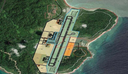
To this end, Air Force Station (AFS) Carnicobar witnessed Chief of Defence Staff General Anil Chauhan inaugurate the upgraded runway at the AFS in January 2026, now capable of deploying Sukhoi Su-30 MKIs, Mirage-2000s, SEPECAT-Jaguars, Lockheed Martin C-130J Super Hercules, Mil Mi-17 V5s and Boeing P8Is. The runways of existing airports in the islands will be expanded to 3,000 kilometres, two new airports will be constructed in Sri Vijayapuram and on Great Nicobar, and all airports will be dual-use, as stated by Lieutenant Governor Admiral DK Joshi. The Indian Government has dropped its plans to extend the runway of INS Baaz due to aviation safety, environmental and societal reasons. Instead, it will build a greenfield dual-use airport with a 3,300-kilometre runway on Great Nicobar Island near Galathea Bay, operated by the Indian Air Force.
The Strategic Synergy of Aircraft Carriers and Forward Bases
India’s naval doctrine envisions the need for three aircraft carriers – two operational and one in reserve – to effectively manage a simultaneous two-front contingency involving China and Pakistan across the northern sector and maritime domain. However, due to current capacity constraints, India operates only two. To compensate and project power effectively, these mobile Carrier Strike Groups (CSGs) rely heavily on India’s natural geography as force-multipliers.
While aircraft carriers are flexible, mobile assets essential for sea control and strategic signalling far from shore, forward bases provide the fixed, sustaining support needed for long-term endurance. The Andaman and Nicobar Islands perfectly fulfil this role, extending India’s operational reach and enhancing the effectiveness of its Armed Forces.
India’s ‘Unsinkable Aircraft Carrier’
The development of Great Nicobar Island is not an act of aggression but a strategic necessity to secure India’s maritime future in the face of China’s expanding regional footprint. The island functions as a highly resilient, cost-effective ‘unsinkable aircraft carrier.’ Unlike expensive and vulnerable man-made ships, this permanent land-based infrastructure cannot be easily neutralised or sunk, thereby raising India’s self-reliance and reducing its dependence on external military assets.
By leveraging this geographic advantage, India achieves several distinct operational and geopolitical objectives:
1. Unmatched Surveillance and Sea Control: Positioned perfectly in the Eastern Indian Ocean, the island allows India to closely monitor adversarial movements across critical Sea Lines of Communication (SLOCs) and physically dominate vital Indo-Pacific chokepoints.
2. Logistical Depth and Rapid Response: The island serves as a permanent launchpad for the rapid deployment of aerial and maritime assets. It provides the necessary logistical depth to sustain long-duration operations without requiring resupply from the mainland.
3. Credible Deterrence and Regional Stability: Acting as a stabilising military platform, the island anchors the balance of power in the region. It ensures continuous deterrence against adversaries, safeguards India’s maritime interests and enables deeper cooperation with like-minded nations to guarantee a free, open and secure Indo-Pacific.
Conclusion
The Great Nicobar Project represents a cornerstone of India’s evolving, multi-layered Indo-Pacific defense strategy. By developing Great Nicobar Island in this manner, New Delhi is accounting for its security, developmental, economic, societal and environmental needs. It allows for unmatched logistical depth, rapid asset deployment capabilities and continuous ‘space-to-seabed’ surveillance over vital SLOCs. Alongside deepening defence ties with regional partners like the Philippines and Indonesia, this strategic vantage point acts as a powerful deterrent to safeguard maritime equilibrium. Ultimately, Great Nicobar Island is an indispensable bridge to a safe, secure and sovereign India, seamlessly connecting the nation’s destiny to the broader oceans.
(The writer is a senior research associate at NatStrat)
–IANS
mr/